
Projects · Buffalo, New York · 2011–2022
The People's Map
Buffalo redrew its council districts behind closed doors. Residents drew theirs in the open.
In 2022 Buffalo had its first population gain since 1950 and a once-a-decade chance to redraw its nine Common Council districts. City Hall mostly kept the old lines. Russell Weaver, the only member of the 2011 commission to vote against those lines, helped residents draw a better map in public, scored every plan on the table, and wrote a 91-page expert report, without pay, for their court challenge.
In brief
A once-a-decade decision
Every ten years Buffalo redraws the nine districts that elect its Common Council. A Citizens' Commission appointed by the mayor and the Council president proposes a map, the Council may change it, and the mayor signs it or vetoes it.
In 2022 that process started late, ran almost entirely out of public view, and ended with a map that changed little from 2011. This page tells the story through Russell's maps and analysis: what the city did, what residents proposed instead, how the plans compare, and what happened in court.
- Role
- Mapmaker and analyst for Our City Action Buffalo; unpaid expert for the residents who sued
- Earlier
- Member of the 2011 Citizens' Commission on Reapportionment, and the only vote against its map
- Work
- Two alternative maps, a comparison memo, teach-ins, an open analysis, a 91-page expert report, and a reply to the city's experts
- Data
- 2020 census counts as adjusted by New York's LATFOR, which counts people in state prisons at their home addresses; Buffalo's 35 planning neighborhoods
- Outcome
- The Council's map became law on August 15, 2022. A state judge dismissed the residents' case on December 19, 2022.
- Map layers
- Every plan's boundaries on ArcGIS Online
01 · 2011
A map built around incumbents
Russell served on Buffalo's 2011 Citizens' Commission. That commission met 15 times in ten weeks, kept a public website, and published a final report that thanked him for his “generous and exceptional contributions.” He was still the only commissioner to vote against its map.
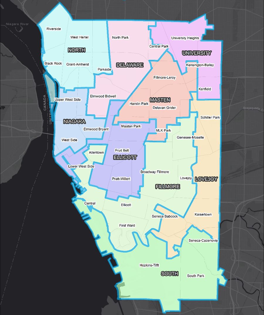
The lines that took effect were, in Investigative Post's words, “a textbook example of gerrymandering.” The Fillmore District wrapped from the East Side around downtown to the lakefront and Allentown, a shape the paper nicknamed “Fillmore's Screaming Eagle.” Ellicott and Fillmore, it reported, were both drawn to give their council members favorable demographics.
A year later Russell made the case for treating redistricting as a planning problem rather than a political one, in an article for the Berkeley Planning Journal.
02 · August 2021 to May 2022
A commission few could find
The 2020 census counted Buffalo's first population gain in seventy years: 280,052 residents in New York's adjusted count, or 31,117 per district.
The data arrived in August 2021, months late because of the pandemic. By Russell's reading of the City Charter, the mayor and the Council president had until the end of September to name the new commission. The Council president named his last appointee in January 2022, and the mayor named his four in late February. The commission was seated on March 2.
It met five times, from April 20 to May 19. No meeting had all nine members present, and no reporter or council member attended any of them. The commission announced its only public hearing on social media with a week's notice. Four days before that hearing, a racist mass shooting at the Tops supermarket on Jefferson Avenue killed ten people.
The hearing went ahead on May 18 and lasted eight minutes. One member of the public came in person. Russell watched the livestream, expecting the start of a public process. Instead the commission put a finished map on a screen, and it approved that map the next day. The city's redistricting web page went up after the hearing, minutes appeared in late June, and there was no written report.
| 2011 | 2022 | |
|---|---|---|
| Seated | March 8 | March 2 |
| Meetings | 15 | 5 |
| Days to a final map | 71 | 78 |
| Public website | Throughout | Posted after its one hearing |
| Public hearing | Held | 8 minutes, four days after the Tops shooting |
| Written report | Yes | None |
03 · June and July 2022
Drawing it in the open
Our City Action Buffalo, a coalition of residents and good-government groups, asked Russell to show what a fair map could look like. He published his criteria first: districts of equal population, compact shapes, Buffalo's 35 planning neighborhoods kept together, and fair representation for the city's Black and Hispanic residents.
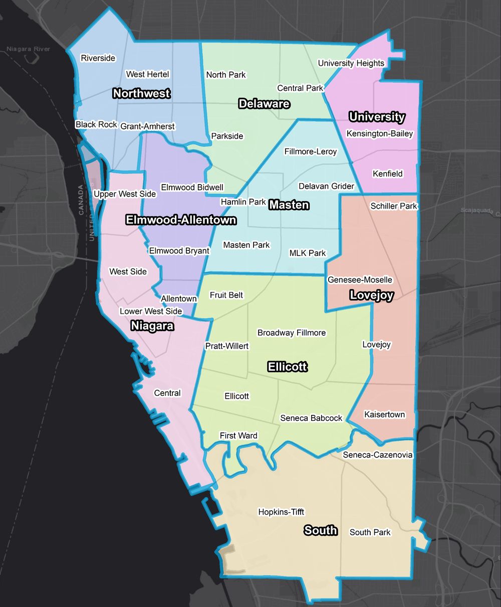
On June 16 he released a memo comparing the commission's map with a first alternative. The coalition took both to residents through teach-ins and illustrated explainers in English and Spanish, then revised the alternative using what people said, including at the Council's June 28 hearing.
Our City Action called the revision the People's Map and filed it with the City Clerk on July 5. More than 800 people signed a petition for it, block clubs and neighborhood business groups backed it, and The Buffalo News editorial board endorsed it.
Drag across the map to compare it with the Council's version. Where the Council's lines split neighborhoods such as Broadway Fillmore, Genesee-Moselle, and Kensington-Bailey, the People's Map keeps each one in a single district.
“That's a way that we can advance racial equity through the plan by increasing the electoral power, potential electoral power of some of our residents.”
Russell Weaver, explaining the residents' map to WBFO, July 1, 2022
04 · The scorecard
Five maps, scored
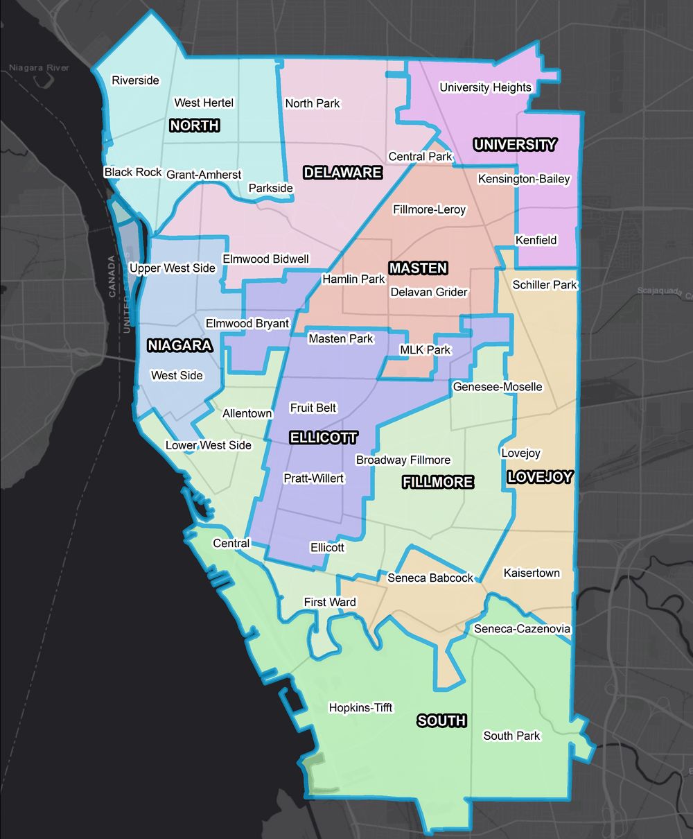
Russell scored all five maps the Council had in front of it against the criteria in the City Charter and state law. The Council's changes made the map less equal in population, less compact, and worse at keeping neighborhoods together. The residents' revisions improved it on nearly every measure.
Population spread
Lower is better
The gap between the most and least populous districts, as a share of the ideal district of 31,117 residents.
Compactness
Higher is better
Median of a composite of five standard shape scores (Polsby-Popper, Schwartzberg, Reock, convex hull, length-width), from 0 to 1.
Neighborhoods kept together
Higher is better
Of Buffalo's 35 planning neighborhoods, how many have at least 90 percent of their land in a single district.
Average neighborhood grade
Higher is better
Each neighborhood is scored by the largest share of its land that lands in one district, then averaged across all 35.
Representation
Each square is one district, colored by the group that makes up the largest share of its residents. The Council's final map was the only plan with three districts where Black residents are the largest group; every other plan had four. Its changes made Lovejoy plurality white, 39 percent to 38 percent. The People's Map kept four, and in Niagara it drew the only district on the table where Hispanic residents are the largest group, tied with white residents at about 31 percent.
WhiteBlackHispanic and white, tied
- 424.8%
- 424.7%
- 324.4%
- 427.0%
- 429.2%
The last column is the highest Hispanic share of voting-age residents in any one district. By voting-age population, the commission's and the Council's maps each had three districts where Black residents are the largest group; both residents' maps had four.
District by district
Bars show how far each district sits from the ideal 31,117 residents, out to five percent either way. Shape is the Polsby-Popper score: 1.00 is a circle, and lower numbers mean more stretched or jagged districts.
Council Map 2
Adopted July 19, 2022 · spread 7.8%
| District | Residents | Off the ideal | Shape |
|---|---|---|---|
| Delaware | 32,150 | +3.3% | 0.35 |
| Ellicott | 32,153 | +3.3% | 0.20 |
| Fillmore | 30,523 | −1.9% | 0.12 |
| Lovejoy | 31,171 | +0.2% | 0.19 |
| Masten | 30,605 | −1.6% | 0.42 |
| Niagara | 32,301 | +3.8% | 0.29 |
| North | 30,360 | −2.4% | 0.31 |
| South | 29,873 | −4.0% | 0.18 |
| University | 30,916 | −0.6% | 0.33 |
People's Map
Filed July 5, 2022 · spread 5.0%
| District | Residents | Off the ideal | Shape |
|---|---|---|---|
| Delaware | 30,879 | −0.8% | 0.47 |
| Ellicott | 31,007 | −0.4% | 0.42 |
| Elmwood-Allentown | 31,438 | +1.0% | 0.47 |
| Lovejoy | 31,816 | +2.2% | 0.42 |
| Masten | 30,783 | −1.1% | 0.68 |
| Niagara | 31,150 | +0.1% | 0.14 |
| Northwest | 31,237 | +0.4% | 0.32 |
| South | 31,495 | +1.2% | 0.30 |
| University | 30,247 | −2.8% | 0.54 |
05 · June 28 to August 15, 2022
A hearing, then two minutes
The Council scheduled its hearing for June 28, the day of the state primary for governor. More than 100 residents came anyway, in person and on Zoom. For two and a half hours, speaker after speaker opposed the Council's map, and not one spoke for it. Seventy pages of written comments said the same. The hearing opened with a council member stating, for the record, that the new lines had to keep every incumbent in their own district.
Two days later the Council called a special session to adopt its map, then canceled it within hours as residents flooded council offices with calls. On July 8 it late-filed an amended map for a vote on July 12. That vote was put off too, and the city's lawyers advised that the Council could consider only maps from the commission, which by then had disbanded.
On July 19 the Council adopted the amended map, Council Map 2, without a roll call. Investigative Post timed the meeting at just under two minutes. In Russell's scoring it was the weakest of the five maps the Council had before it.
The mayor held his own hearing on August 3, at 10:30 on a weekday morning on a college campus. About 70 people came, and all but one speaker urged a veto. Some 200 written comments, 207 pages in all, opposed the map, and none supported it. The mayor signed it on August 15, saying its opponents did not represent a “significant” share of the city.
“The critics are right. The Buffalo redistricting plan that was the focus of a public hearing on Tuesday should be thrown out and the work restarted.”
The Buffalo News editorial board, June 29, 2022
“A coherent blueprint for productive change.”
The Buffalo News editorial board on the People's Map, urging a veto, August 2022
06 · Inside the adopted map
Who the new lines moved
Nearly nine of every ten square miles stayed in the same district. Russell's report asked where the changes did happen, and who they moved.
Two districts stood out. In Ellicott and Fillmore, the odds that people in a district's long-standing core were moved out were more than double the odds in the rest of the city.
The people moved were not a cross-section. In Ellicott, more than half of the 3,862 residents drawn out were Hispanic, while three-quarters of the 5,916 drawn in were white. In Fillmore, nearly half of those drawn out were Black and more than half of those drawn in were white. Fillmore's voting-age population went from plurality Black in its historic core to 45 percent white under the new lines.
Russell then matched the moved areas to past primary results. Ellicott shed precincts where its council member had won 43 percent of the vote in 2010, the only primary in which he faced a serious challenge, and kept precincts where he won 67 percent. Fillmore shed precincts that gave Black candidates 63 percent of the vote in the 2019 primary its council member won, and kept precincts where they won 25 percent.
The report concluded that both districts were redrawn to protect their incumbents, at the expense of Hispanic residents in Ellicott and Black residents in Fillmore. The judge's ruling did not address those findings, as Our City Action pointed out at the time.
WhiteBlackHispanicAsianOther or multiracial
Ellicott
Fillmore
Residents drawn into and out of each district by the adopted map, compared with the 2011 lines, by race and ethnicity. From Russell's expert report, October 2022.
07 · October to December 2022
In court
On October 18, 2022, Our City Action Buffalo, the University District Block Club Coalition, and nine Buffalo voters sued the Council, the mayor, the city, and the Erie County Board of Elections. Their petition argued that the city ran a late, closed process in violation of the City Charter and the state Open Meetings Law, and it incorporated Russell's 91-page, 260-paragraph expert report, which he wrote without pay.
In December the city answered with two outside experts. One compared the Council's map with 100,000 computer-simulated plans; the other critiqued Russell's measures. Russell's reply argued that neither engaged the question before the court, which was whether the Council's choices, given what was in front of it, followed the law. The simulated plans were never part of the public process. The city's experts also relied on a set of 55 neighborhoods that had never been made public before the city's December filings.
On December 19, 2022, State Supreme Court Justice Timothy J. Walker dismissed the case with prejudice. He ruled that the city's timing was reasonable, that the open-meetings claims came too late and did not apply to the commission, and that the question was not whether the residents' maps were better but whether the Council's map substantially complied with the law. The map, he wrote, “falls well within the range of options the Common Council was entitled to select.”
Our City Action said the ruling left the record's other concerns unaddressed, including incumbent protection, and that it would weigh its options.
“Redistricting authorities ignore the public at their peril, for comparison maps drawn by the public allow courts to evaluate when politicians have subverted the law for private or partisan gain.”
Michael P. McDonald and Micah Altman, The Public Mapping Project (2018), quoted in Russell's reply to the city's experts
“A redistricting map devised by the people's elected representatives takes precedence over a map proposed by a vocal minority of residents.”
Justice Timothy J. Walker, December 19, 2022
08 · After
What it left behind
Our City Action announced in January 2023 that it would appeal, then dropped the challenge. The Council's map took effect for the 2023 Council elections and will set Buffalo's districts until the lines are redrawn after the 2030 census.
The city's charter review left redistricting alone. None of the 11 charter changes on the November 3, 2026 ballot deals with how districts are drawn or who draws them.
What residents built in 2022 stays public: the maps, the scores, and the methods. Whoever draws Buffalo's next map will have a worked example of an open process to follow, and a record of what a closed one looks like.
For Russell the fight joined two threads of his work: the case for treating redistricting as planning, which he first made in 2012, and the free public data tools he builds at the Cornell ILR Buffalo Co-Lab.
Timeline
Eleven years, one map
The 2011 Citizens' Commission is seated, with Russell as one of nine members.
After 15 meetings the commission publishes its report. Russell casts the only vote against its map.
The 2020 census redistricting data arrive, months late.
The city's call for commission nominees closes.
The Council president names his last appointee.
The mayor names his four appointees.
The 2022 commission is seated.
A racist mass shooting at the Tops on Jefferson Avenue kills ten people.
The commission's only public hearing lasts eight minutes.
The commission approves its map and sends it to the Council.
Russell's memo compares the commission's map with a residents' alternative.
More than 100 residents oppose the Council's map at a hearing held on primary day.
A special session to adopt the map is called, then canceled.
The People's Map is filed with the City Clerk.
The Council delays its vote. City lawyers say it can consider only the commission's maps.
The Council adopts Council Map 2, unanimously and without a roll call.
At the mayor's hearing, all but one speaker urge a veto.
The mayor signs the map into law.
Residents sue, with Russell's 91-page expert report.
The city answers with two outside experts. Russell replies days later.
Justice Timothy J. Walker dismisses the case.
Our City Action announces an appeal, which it later drops.
Sources
Documents and coverage
Documents
- DecisionOur City Action Buffalo, Inc. v Common Council of the City of Buffalo, 2022 NY Slip Op 22389
- Court filingsErie County Supreme Court, Index No. 812652/2022, including Russell's report and reply
- Map layersEvery plan's boundaries on ArcGIS Online
- AnalysisAn Open Analysis of Common Council Redistricting Plans for Buffalo, NY, Our City Action Buffalo, August 24, 2022
- The campaignOur City Action Buffalo: The Fight for Fair Maps
- BackgroundGerrymandering Politics Out of the Redistricting Process, Berkeley Planning Journal, 2012
Interviews and talks
- WNY Data God Dr. Rusty Weaver Podcast · The Square
- Redistricting and Why It Matters Radio · The Public Good, Partnership for the Public Good
- Buffalo Common Council Redistricting, with Jillian Hanesworth Radio · The Public Good, Partnership for the Public Good
- Redistricting and Representation Radio · WBFO, Buffalo, What's Next?
- More on Redistricting and Partnership for the Public Good Radio · WBFO, Buffalo, What's Next?
- People-Led and Data-Driven Talk · eCornell Keynotes
Coverage
- Buffalo's gerrymandered Council districts Investigative Post · Geoff Kelly
- Council catches hell on redistricting plan Investigative Post · Geoff Kelly
- City's proposed redistricting map falls short of a reasonable standard of fairness The Buffalo News · Editorial Board
- Buffalo Common Council backs off on proposed new district lines, an apparent victory for activists WBFO · Mike Desmond
- Buffalo Community Activists Show How to Fight Gerrymandering The Nation · Geoff Kelly
- Council adopts new district lines Investigative Post · Geoff Kelly
- Buffalo could have had a much better redistricting map. It got politics as usual. The Buffalo News · Editorial Board
- Brown says Council map has seven majority-minority districts, but activists say he's counting minorities who can't vote yet WBFO · Mike Desmond
- Activists sue Buffalo over Council redistricting Investigative Post · Geoff Kelly
- Judge rejects lawsuit filed against Buffalo Common Council WGRZ
More coverage 23 stories
- Fight before Buffalo Common Council on district reapportionment in the wake of the 2020 Census WBFO · Mike Desmond
- Buffalo Common Council postpones vote on redistricting plan Spectrum News 1 · Viktoria Hallikaar
- Buffalo Common Council Summary: Week of June 27, 2022 Partnership for the Public Good · Sydney Browne
- Council lost, activists take redistricting rudder Investigative Post · Geoff Kelly
- Buffalo residents call for revised redistricting map Spectrum News 1 · Brianne Roesser
- Our City Action Buffalo's Alternative Proposal Per Redistricting Buffalo Buffalo Rising
- Bad governance, poor politics Investigative Post · Jim Heaney
- Buffalo Common Council pushes off decision on reapportionment after raucous meeting WBFO · Mike Desmond
- Pausing the Buffalo redistricting vote allows time to fix major problems The Buffalo News · Editorial Board
- Buffalo Common Council set to vote on new district map Tuesday at noon WGRZ
- Buffalo Common Council approves new district lines, setting up likely court battle WBFO · Mike Desmond
- Buffalo Common Council votes to approve new district map Spectrum News 1 · Viktoria Hallikaar
- Buffalo redistricting could be a 'test case' for new voting rights law Spectrum News 1 · Ryan Whalen
- Public hearing on Buffalo's redistricting plan turns contentious The Buffalo News · Deidre Williams
- Buffalo Mayor Byron Brown faces public criticism during heated redistricting hearing WBFO · Emyle Watkins and Tom Dinki
- Brown should admit that city's redistricting process was flawed and veto the map The Buffalo News · Editorial Board
- Buffalo Mayor Byron Brown signs controversial Council district map into law WBFO · Tom Dinki and Mike Desmond
- NYC new redistricting 'offers opportunity to empower residents' Cornell Chronicle
- Lawsuit filed over Buffalo redistricting map Spectrum News 1
- City of Buffalo sued by citizens claiming redistricting process 'failed to meet basic requirements of the law' JURIST · David DeNotaris
- New filings in reapportionment lawsuit; City of Buffalo flip-flops on open meeting status WGRZ
- Court fight over Buffalo's redistricting draws sharp exchanges from rival experts The Buffalo News · Deidre Williams
- Not much change afoot for Common Council Investigative Post · Geoff Kelly
Scores, district tables, and the analysis of who moved come from Russell's expert report of October 18, 2022, and his open analysis of August 24, 2022, both built on New York's 2020 LATFOR redistricting data. Council members are described by district rather than by name.